


HAYES TWP Voting District, Ida County, Iowa
About
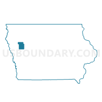
Outline

Summary
| Unique Area Identifier | 582357 |
| Name | HAYES TWP Voting District |
| County | Ida County |
| State | Iowa |
| Area (square miles) | 35.75 |
| Land Area (square miles) | 35.75 |
| Water Area (square miles) | 0.00 |
| % of Land Area | 99.99 |
| % of Water Area | 0.01 |
| Latitude of the Internal Point | 42.25599040 |
| Longtitude of the Internal Point | -95.38032850 |
Maps


Graphs
Select a template below for downloading or customizing gragh for HAYES TWP Voting District, Ida County, Iowa


Neighbors
Neighoring Voting District (by Name) Neighboring Voting District on the Map
- BLAINE TWP Voting District, Ida County, IA
- CORWIN TWP Voting District, Ida County, IA
- GRANT TWP Voting District, Ida County, IA
- MORGAN TWP W/O SCHLESWIG Voting District, Crawford County, IA
- OTTER CREEK TWP W/O KIRON & SCHLESWIG Voting District, Crawford County, IA
- RICHLAND TWP Voting District, Sac County, IA
- STOCKHOLM TWP Voting District, Crawford County, IA
- WHEELER TWP Voting District, Sac County, IA
Top 10 Neighboring County Subdivision (by Population) Neighboring County Subdivision on the Map
- Corwin township, Ida County, IA (2,389)
- Otter Creek township, Crawford County, IA (1,350)
- Richland township, Sac County, IA (1,197)
- Blaine township, Ida County, IA (428)
- Morgan township, Crawford County, IA (207)
- Stockholm township, Crawford County, IA (199)
- Grant township, Ida County, IA (181)
- Hayes township, Ida County, IA (180)
- Wheeler township, Sac County, IA (179)
Top 10 Neighboring Unified School District (by Population) Neighboring Unified School District on the Map
- Denison Community School District, IA (10,419)
- Battle Creek-Ida Grove Community School District, IA (3,905)
- Odebolt-Arthur Community School District, IA (2,006)
- Schleswig Community School District, IA (1,670)
Top 10 Neighboring State Legislative District Lower Chamber (by Population) Neighboring State Legislative District Lower Chamber on the Map
- State House District 52, IA (28,211)
- State House District 55, IA (28,147)
- State House District 51, IA (27,718)
Top 10 Neighboring State Legislative District Upper Chamber (by Population) Neighboring State Legislative District Upper Chamber on the Map
Top 10 Neighboring 111th Congressional District (by Population) Neighboring 111th Congressional District on the Map
Top 10 Neighboring Census Tract (by Population) Neighboring Census Tract on the Map
- Census Tract 802, Sac County, IA (2,719)
- Census Tract 903, Ida County, IA (2,378)
- Census Tract 702, Crawford County, IA (2,257)
- Census Tract 902, Ida County, IA (2,161)